

Study Overview
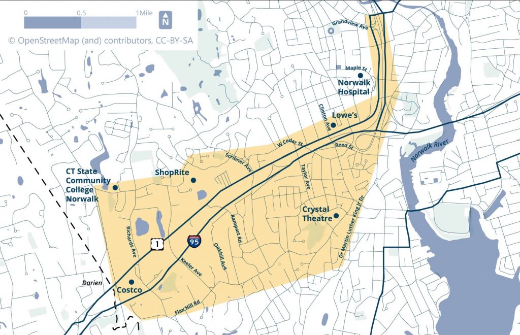
The Norwalk Route 1 Corridor Master Plan Study establishes a bold, implementable vision for transforming one of Norwalk’s heavily travelled corridors into a safer, more efficient, and more welcoming multimodal gateway. Covering a 2.9-mile segment of U.S. Route 1 (Connecticut Avenue and Van Buren Avenue) from the Darien town line to Belden Avenue, the study recognizes Route 1’s dual role as both a regional arterial and a local main street. Today, the corridor carries 13,000–20,000 vehicles per day while also serving thousands of people traveling by bus, walking, and bicycling. Between 2019 and 2023, the corridor experienced approximately 1,400 crashes, including fatalities and serious pedestrian and bicycle injuries, underscoring the urgent need for change.
Developed through a partnership between WestCOG, the City of Norwalk, the Connecticut Department of Transportation, and the Norwalk Transit District, the plan responds directly to these challenges with a comprehensive, corridor-wide redesign. Key recommendations include completing sidewalks on both sides of Route 1, adding high-visibility crosswalks at all signalized intersections, building a continuous multi-use path for bicyclists and pedestrians, enhancing bus stops with shelters and seating, and modernizing traffic signals to reduce stop-and-go congestion while improving pedestrian safety. The plan also proposes “right-sizing” portions of the roadway by reallocating excess travel lanes to medians, green infrastructure, and multimodal facilities. Several intersections along the corridor also have recommendations for redesigns to improve visibility and reduce crash risk.
Recognizing the scale of investment required, the study outlines a phased implementation strategy spanning near-, medium-, and long-term actions, paired with cost estimates, funding opportunities, and identified implementation partners. Together, these recommendations form a practical roadmap to improve safety, mobility, economic vitality, and quality of life along Route 1, positioning the corridor to better serve residents, workers, visitors, and the broader region for decades to come.
For more information, contact Kristin Floberg at: kfloberg@westcog.org
Project Deliverables
Existing Conditions Report, Appendices
Final Report, Executive Summary Story Map
Appendices:
D. Intersection Capacity Analysis
E. Adaptive Traffic Control System (ATCS) Comparison Memorandum
F. Cost Estimate Detail Sheets
G. Evaluations, Permitting, and Compliance
Project Advisory Committee
The PAC consists of representatives from the City of Norwalk, WestCOG, Norwalk Transit District, and CTDOT.
PAC Meeting #1: Meeting Summary
PAC Meeting #1: Vision and Goals
PAC Meeting #2: Meeting Summary
PAC Meeting #4: Meeting Summary
Public Engagement
May 20, 2024 Public Meeting Presentation
May 20, 2024 Public Meeting Summary
August 7, 2024 Business and Transit Outreach Summary
March 24, 2025 Public Workshop Presentation and Draft Concepts
March 24, 2025 Public Workshop Summary